Figure 1.3.1
Introduction to Earth Sciences I
1.3 The Earth's Strength
Although it is a fundamental quantity of any material object, the question, "how strong is the Earth" was not really addressed very closely until fairly recently. The answer, it would seem on first thought, is that it is almost infinitely strong - at least the rocky parts of the continents. For most common purposes, the Earth is indeed very strong. However, we are fairly confident that the Earth's (outer) core is liquid and that volcanic rocks rise from deep in the Earth so we know that it is not completely rigid through and through. We also know from the bulging middle shape that it must be somewhat soft in gross properties. How can we get an idea of the Earth's strength? There are several ways and in each we have to analyze experiments the Earth is performing on itself.
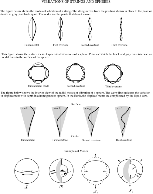
1.3.1. The Earth Rings Like A Bell
Given a sufficiently large earthquake, like the Good Friday earthquake in Alaska in 1964, which had a magnitude of 8.6, the entire Earth actually vibrates. It is fairly intuitive that the amplitude and "tone" of the vibrations must relate in some way to the material properties of the Earth. Imagine three tuning forks, one made of aluminum, one of steel and one of titanium, each struck equally hard. The pitch of individual tuning forks will be different and the time it takes for the tone to die away will differ also. The aluminum fork will make a dull thud and the sound will die out quickly; the titanium fork will make a high pitched ring and vibrate for a long time.
In the Earth these vibrations are called "normal modes" or "free oscillations." The normal mode period for a solid iron ball as large as the Earth can be calculated. In 1911 A.E.H. Love made the calculations and determined the period would be about an hour. That is, struck hard enough the whole Earth would vibrate in and out every hour. In 1954 Hugo Benioff announced that he thought he had detected a normal mode of 57 minutes from the Kamchatka earthquake of that year, but the first real proof came in 1961 by Bruce Bolt who clearly identified a 54 minute mode associated with the 1960 Chilean earthquake. He also saw much shorter period vibrations that represent harmonics or overtones of the fundamental long period mode.
Figure 1.3.1
The fundamental mode vibrations can tell us about the properties of the whole Earth. The harmonics or overtones give us insight into the deeper parts of the Earth. It is usual to calculate on a computer the expected harmonics for various Earth structures and compare them to observations. That is, the process follows a forward approach. Normal mode inverse methods are available also but they are difficult to implement.
As we started off at the beginning, we can think of this in terms of information types - we observe normal mode vibrations and using a theory of elasticity we can infer parameters associated with the Earth's strength.
1.3.2. The Earth Responds To The Moon - Earth Tides
While it might seem incredible, the Earth as a whole responds to the pull of the Moon's gravity. The moon is, of course, responsible for the ocean tides (and we will study these a little later in topic 2) but its gravitational pull is strong enough to distort the shape of the solid Earth also. The Earth's surface actually rises up a little when the moon is overhead. While the ocean tides have a range of several tens of feet in places and are commonly several feet, the surface of the solid earth moves only about 10 cm at most; much less in many places.
Obviously the moon is exerting the same pull on the oceans as it is on the solid earth, and the amount it yields is a measure of the strength of rock compared to water. In the same way, as we described for normal modes, we can calculate the yielding that would be associated with a fully rigid Earth and one with yeilding. It is therefore possible to determine just how soft the center is by matching predictions and observations.
The distortion is described by so-called Love numbers after the same A.E.H. Love who studied normal modes. These Love numbers are a measure of the Earth's yield strength.
1.3.3. The Earth Bends When A Weight Is Placed On It
We can learn a lot about the strength of materials by the way they bend. Our instinct is always to try to distort an object to get a sense of how strong - resistant to forces - it is. When we squeeze melons at the fruit stand to make sure they are not over ripe we are measuring their strength, knowing that they get soft if they are too ripe.
We cannot really do that for the Earth other than in samples of rocks from near the surface from which we learn that most crustal rocks are indeed very strong. We build buildings out of rocks. Fortunately the Earth has performed some bending experiments for us that can be used for this purpose.
Volcanic Islands -
The color map below shows the shape of the Pacific
ocean floor around the Hawaiian Islands. The image was created by a software
tool that can be accessed at http://www.ldeo.columbia.edu/dees/ees/lithosphere/index.html.
This is the site that supports one section of the course for Earth Science concentrators.
Click on the image in the upper right and use the Zoom function to home in on
different parts of the world. Just click on the image to re-center the map.
The brown and yellow colors show elevation above sea level and the blue green
colors are depths below sea level. You see the chain of the Hawaiian Islands
with the "Big Island" to the southeast in brown shades. Look closely
around the islands and you will see that the ocean gets quite deep immediately
adjacent to the islands as you might expect. But there is also a diffuse halo
of shallower ocean floor around the island chain. The black and white figure
below shows a cross section through the main island.
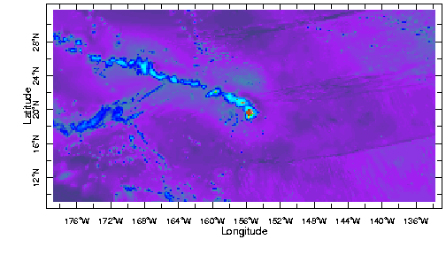
Figure 1.3.2
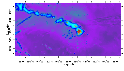
Figure 1.3.3
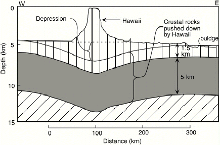
Figure 1.3.4
The formation of a volcano involves the transfer of a very large amount of molten material from deep in the Earth to the surface. Lava erupts at the surface and builds up in a pile that is extremely heavy. The weight presses down on the Earth's surface and, if the volcano is large enough, will cause the layers beneath to bend downward. This process is very apparent in the Hawaiian Islands where the weight of the newly forming islands is pushing the layers beneath downward. This means that the layers must have finite strength or they would carry the load without changing shape. The amount by which the underlying layers bend is a measure (indirect) of their strength - the more they bend the weaker they are.
In fact, almost all the islands in the Pacific Ocean show evidence that they are bending the layers beneath. Bending seems to be greater in some places than others but the shape always seems to be much the same - a depression around the island and a bulge further out. This depression and bulge shape tells us that the layers beneath are deforming in an elastic manner. By this we mean that if the weight were removed the Earth would spring back (slowly) to its original shape. It is the size of the depression and the distance from the islands to bulge that tells us the strength, or rigidity, as it is usually stated.
When we look at these strength measures from islands in the Pacific we find there are systematic patterns. The layers are weaker near to mid-ocean ridge spreading centers (more on this later) and stronger further away. What we are seeing is that the Earth's outer layers get stronger as they get older - basically, they freeze harden.
Mini-Quiz:
1.3.4. The Earth Rebounds When A Weight Is Lifted.
Massive Ice Sheets -
Above we noted that the weight of volcanoes can be used to give a measure of the Earth's strength which is an elastic property. Removing the weight would cause the Earth to return to its original shape.
The Earth has also done this experiment. During the last ice age huge ice sheets covered much of Europe and North America. Manhattan was under about a mile of ice. Their weight depressed the crust beneath just as Hawaii depresses the crust. As the current inter-glacial period began about 10,000 years ago, the ice sheets melted and retreated back to their present position. In doing so they released a massive weight from the Earth. That weight had depressed the layers beneath as it presently does in Greenland and Antarctica where the rock surface beneath the ice is actually well below sea level.
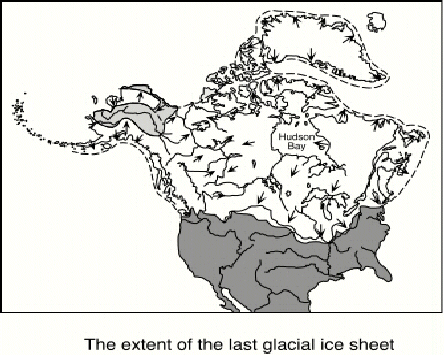
Figure 1.3.5
When the ice sheets were present the Earth was depressed; as they retreated the Earth's surface rebounded. The retreat was fairly rapid. The figure below shows the extent of the ice sheet in what is now Northern Europe and Scandinavia at four times in the recent past as the last glacial period ended (a is 14,000 years ago, b is 13,000 years ago, c is 12,000 and d is 11,000). The load of the ice sheet was removed fairly quickly but the rebound was not instantaneous. The surface that had been depressed by the ice sheet rebounded slowly as the deep layers of the mantle beneath flowed back. The surface is still rising today, 10,000 years after the ice sheet has all but disappeared. The rate of uplift - fast or slow - is a measure of the ability of the deep layers to flow.
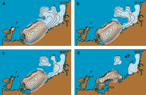
Figure 1.3.6
Basically, when the weight depresses the outer layers of the Earth, deeper layers have to flow outward to accommodate the layers, squeezing them for space. When the weight is released the deep layers flow back. The rate of flow measures (indirectly) the viscosity of the deep layers.
The best evidence we have for this flowing of deep layers is the uplift in Fennoscandia. We know the land is moving upward because we can see evidence for beach deposits in layers high above sea level. Because these can be dated we can measure the rate of uplift and this is a fairly direct measure of the rate of flow of the layers beneath.
Mini-Quiz:
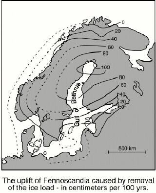
Figure 1.3.7
What is found from these studies is that the deep layers of the Earth must be quite fluid-like on time scales of several tens to hundreds of thousands of years. The outer surface is rigid, but beneath there is a region where the layers can flow relatively readily. This property of the Earth becomes key to understanding the global process of plate tectonics that both Professor Langmuir and I discuss. The outer rigid layer is called the lithosphere (lithos meaning rock) and the layers below capable of flow are called the asthenosphere.